Tuesday, September 02, 2008

Hokusai and Hiroshige


Wondering through Barna, I stumbled upon this exhibition at la Pedrera of Japanese wood prints from the Ukiyo-e school (Edo period, 17-19th centuries). Brought to the light from the dusty shelves of Bibliotheque Nationale de France, these prints are incredible in their mastery of execution and strong feelings they manage to convey with a lightness of a pen stroke. They create an atmosphere of refinement and fantasy, and are based on totally different premises than art in the West.

Two painters that both worked in the first half of the 19th century summerized the beauty of this trend, derived from caligraphy, and that has a distant relation to symbolism and romanticism that was going on in Europe at the same time : Hokusai and Hiroshige.

Hokusai, who started painting at around six, and used over thirty different names during his life, is most famous for his series of thirty six views of Mount Fuji. The sacred Japanese vulcano obsessed him like lillies, hay stacks or cathedrals did Monet. He also published a very famous book of Mangas (12 voloumes of comic sketches) that has influeced modern Japanese manga production.


Hiroshige became famous soon after Hokusai and continued ukiyo-e tradition after Hokusai died. Hiroshige, a favorite of Van Gogh´s and other impressionists, started first as a royal fireman, and devoted his life to art the year Hokusai published his series of Mount Fuji views. One of his most famous work is a series illustrating his journey from Edo to Kiyoto, the so called Tocaido road. More of this series here.

In a nutshell, the exhibition is definitely worth a stop, it is still on until September 14th, and it is free!

Saturday, August 30, 2008

Home Sweet Home in Barcelona


I have moved again and now i am a proud renter of a home sweet home in the exciting city of barcelona! This is the view from my window:

The next step is to get a bike and get very strong on these hills!

Thursday, August 21, 2008

Musts of Peru and Bolivia

- Learn Spanish

FOOD and DRINK
- if you have patience for small bones, try cuy, the peruvian delicacy, our pet, the guinea pig
- peruvian suchi, or ceviche in a cevicheria, as well as chupe de camarones, milk soup with shrimp (specialty of Arequipa)
- Peru's own fast foods offering pollo a la brasa
- alpaca or lama steak, quinea soup, and stuffed peppers are other national dishes
- various desserts with dulce de lece, cooked condensed milk, such as tejas in Ica
- drink Cusquena in Cusco, Arequipena in Arequipa, Pacena in La Paz (beer)
- drink purple chicha in Peru or Bolivia, sweet hydrating drink made up of mais
- drink mate de coca or munja (tea)
- enjoy lemonade with egg white and its neighbor, the famous Pisco Sour cocktail

SHOPPING
- a hat is a must, most beautiful ones i found on Taquile island, 30 soles
- beautiful sombreros made me loose another $20 in the villages of Colca canyon
- torrero de Pucara - the sacred cow that usually sits on the rooftops


- other alpaca goodies, quality = price...
- coca leaves, tea, cookies, sweets

HOTELS we stayed in
- Cuzco: Artesano in San Blas, 30 soles for two, without really warm water
- Puno: Duque´s Inn, 30 soles for two, warm water
- La Paz: Millenio, 54 boles for two, without really warm water
- Potosi: Hostal Compania de Jesus, 110 boles for two, in an old abbey, warm water
- Arequipa: Hostal Santa Catalina, 45 for two, warm water, our favorite
- Ica: Hostal Rocha, 35 soles for two, with parrots and a monkey, warm water
- Huaraz: Leiba, 30 soles for two, warm water
- Lima: Kaiser family B&B, $30 for two, warm water

Favorite RESTAURANTS in Huaraz

- Brasa Roja for pollo a la brasa, best price/quality mix, awesome jogos con leche

- Pachamama for games (pool, table tennis, chess)

- Creperie Patrick for their Nutella crepe

- California Cafe for breakfast, with awesome real american pancakes and good coffee

- Cafe de los Andes for juices, coffee and sandwitches

- BB Pizza for pizza and perfect flamenkuch

Good bye Peru, hasta la vista, so far we will concentrate on digesting your lessons...

Tuesday, July 29, 2008

Quitaraju, North Face Direct

Next on our list, we decided to go for another snow experience in the Santa Cruz valley. Two interesting and rather classic objectives beckoned to us - Alpamayo (below) and Quitaraju, both situated in the East end of this valley.


Alpamayo, the ´muddy waters´in Quechua, became by chance known as the most beautiful mountain in the world. Many things happened by chance for this mountain. In the early days it was approached from its north side, from which it does look like a perfect Paramount pyramid. However today one rarely gets to see it that way, only when doing the Cedres valley trek.

The word got out though, and now it has become one of the most popular summits in the Cordiliera Blanca. The same legend goes about the routes on Alpamayo - the classic Ferrari route was first climbed more to the right from where the route goes now. The French Direct route was named after two French killed by an avalanche on it instead of the two Americans claiming its first ascent. A mountain with a story...


Santa Cruz valley is not only popular with mountaineers for the Alpamayo, Quitaraju, and Artesonraju approach, but also with trekkers that do Santa Cruz- Llanganuco circular trek in 4 days. It is also one of the longer valleys in Cordiliera Blanca without a road. It is around 20km and 2000m elevation gain to get to the Alpamayo base camp at 4 300 meters, and by then you are far from done, as there is a moraine camp at 4 900 at then a col camp at 5 400 before even starting to talk about the summit attempt.


We did the approach in 3 days, i guess it is possible in two, but you have to be fit and strong. We used a burro and an arriero for the first time to give ourselves all chances of success (picture of the mule and its driver above). It all starts in the obscure village of Cashapampa, reached by a bumpy ride in a shared taxi from Caraz, overall 3.5 hours from Huaraz. Again, the prices are rather random here - for more or less the same ride you pay 15 soles for two to Cashapampa village, 30 soles for two to the Llanganuco valley, and 60 soles to the Paron lake - go figure...

The hardest part of the approach is getting to the col camp, not only because of its attitude (5 500 meters at the Col), but also because of around 2 pitches of grade 3 ice to negotiate among bergshrunds with full packs. Apparently this col approach is getting worse every year, again due to Global Warming. Below view from the col trail:


The col camp is situated on the glacier, first time we are setting our tent on snow on this trip! Snow with all its pleasures, like this toilet spot a couple of meters from camp:


The col camp gives access to both, Alpamayo and Quitaraju, just down the glacier and turn either right or left, respectively. For neighbors, we shared the Col with another two parties - the two Swiss girls and their porter, and two New Mexicans. The American guys just got down from Alpamayo´s French Direct route as the Ferrari route has not been done this year due to a big bergshrund hanging just over its top-out. The Swiss girls were planning to go for the same route the next day, which left us with Quitaraju. The easier ridge route on Quitaraju was apparently as well out of condition because of the gaps in this ridge, which made us go with the North Face D- way up.

The weather finally has been spoiled a little, and clouds covered us practically each day around 10-11am. It even snowed one night to make us a little bit nervous.


The usual wake-up at 3 am, and off we go to our first 6000ender. The approach is a long traverse through the glacier under the col and some unhappy-looking bergshrunds. The route itself is a straightforward snow slope at around 40 degrees in average. It is around 9 pitches that we simulclimbed to the summit ridge. The most exciting about Quitaraju is its summit ridge. It resembles a little bit Kufner on Mont Maudit, a knife-blade cornice. Unfortunately, we had to do it in the clouds, and thus the views were blurred. The bizarre feeling of walking on the knife blade was still there, especially when your head is buzzing from the attitude.

We did get a couple of seconds of visibility to make a summit picture with the Santa Cruz summit in the background:

As usual, our plans to do the second mountain (Alpamayo) from the same camp were foresaken by the fatigue after the first mountain. We thus decided to go down the next day instead of trying the a bit more difficult and icy French Direct. The way down is definitely more fun than up, and the views are gorgeous - here is Ren on the first rappel from the col:

We did screw up arrangements with our burro driver that was supposed to come for us one day too late, which made us carry the backpacks all the way to Cashapampa, still managing the way down in 2 days instead of the 3 we used up for the approach. Overall, this made up for the longest expedition ever - 6 days for one mountain, we are becoming real mountain people!

Tuesday, July 22, 2008

La Esfinge, the Normal Route

Another objective on our list has been the rock called La Esfinge, the Sphinx. It is just a small outcrop at the beginning of the Paron valley, mirroring the Torres de Paron on the other side of the quebrada. Its summit is a mere 5 320 meters high, but to get there you have to climb around 500 meters of vertical terrain.


To get to the Paron valley from Huaraz it takes a little bit longer than to the Llanganuco valley. First, you have to go to the town of Caraz in 2 hours by combi, and than take a taxi for an expensive 60 soles for one-way ride to the Laguna Paron. There are few tourists in this valley and less villages on the way, thus the high transportation cost. It is also wise to pre-arrange for the taxi driver to fetch you back from the lake, if not it is an 18-km walk back down to the nearest village...


The Paron lake is home to a hydro-electric station, that is why there is a manned hut at the base, but not much else. The approach to Esfinge base camp is not bad though, it only goes from 4 200 meters (the lake) to 4 700 meters in around 2-3 hours. The base camp is still around 1 hour away from the sunny east face of the Esfinge (sun from 6 am to around 2 pm). Below is the view upon the Piramide (to the left) and Chacraraju mountains from the base camp:


We planned to climb the Normal Route, 20-pitch ordeal, in two days, given our slow predispositions. The first ascent party apparently spent 9 bivies on the wall, although the first free ascentionists did the route in 2 days, and numerous strong parties do it in one. Howling has been rather painful, as the route is mostly slabby and Renaud was leading on both our 60m ropes, meaning that I had to climb with a backpack and howl the other bag in the same time.


We had good luck with the weather that held fortunately sunny for both days. After Pisco, we were well acclimatized to the altitude and were comfortable bivying at 5 000 meters. Climbing has been hard, long, and gruesome, maybe because we have not touched rock for the last month or so. We did make it to the top on the second day:


As we needed a little bit of adventure, we ignored the guidebook´s recommendation to follow the ridge to its lowest point and make three rappels to the ground. The ridge looked snowy for my sandals, and there were new rap stations just down under the summit. The ground looked close by...After 12 60-m rappels and some ranting we finally reached it by the night fall. View of the Huandoy Norte fading away with the last purple sunshine:


The route those rappels followed through the compact slabby orange granite looked incredible. Not sure which route it is, maybe the ´Welcome to the Slabs of Korikancha´? Anyway, congrats to the FAionists, it looked amazing and hard work.

Sunday, July 13, 2008

Cordiliera Blanca - Pisco, First Mountain

Upon our arrival to Huaraz, the Chamonix of Peru, we decided to start our mountaineering with Pisco, one of the easiest mountains at only 5 760 meters at the summit. Still the highest point we both ever climbed up to. Below is the mountain, the Normal route climbs the long ridge on the left of the picture.


It has been named Pisco because of the famous Peruvian alcohol, pisco, consumed immoderately to celebrate the first ascent. Pisco was actually born when the Spanish king forbade the peruvians to make wine because it competed with production back home. The peruvians invented this crystal-clear alcohol to compensate. The best part about pisco is Pisco Sour, the cocktail with lime and egg white, the delicious invention definitely worth a try or two.

Back to our mountain, one of the reasons why Cordiliera Blanca is so popular with the mountaineers is the ease of the approaches. It does not boast the lifts of the Alps, but it is also far from several days of trekking necessary in the Himalayas. 1.5 hour combi ride from Huaraz to Yungay, and another 1.5 hour cab ride up the Llanganuco valley gets one to the base of the approach, at around 3 900 meters. The view of Chopicalqui, another 6 000-ender around, from the glacier:


At the end of the Llanganuco valley, at the taxi stop, several burros and their arrieros (mules and their drivers) await to carry your bags up to the Refugio and the base camp at 4 600 meters. Proud and poor, we became self-made sherpas and carried the heavy backpacks up, to the moraine camp at 4 900 meters. Around 4-5 hour effort that requires to be acclimatized to the altitude and in full possession of the carrying enthusiasm! The destination, cold and high moraine camp:


The reward, as always in the mountains, of this high camp, are the views, especially at the sunset. This is Chopicalqui, again, just as the moon appeared and the clouds settled in at around 6 pm (it is dark early here as it is winter now in the Southern hemisphere):


The next day, the departure is at around 2 - 3 am, the usual mountaineering obligation. The climbing is mainly walking, with a couple of cravasses to negotiate on the way. We had around 8 japanese tourists roped together just in front of us (Pisco with Ishinca and Urus are the most popular guided excursions for the wealthy thrill-lovers), that were even harder to negotiate than the crevasses. This is the ´road´to the top:


The altitude finally got to us a couple of hundred meters below the summit, making the last 200 meters a grueling and slow affair. I dragged Renaud and he dragged me, and somehow we made it to the top. The 360 degree panorama, just as the sun started rising, is rewarding. Below is myself with Huascaran Sur and Norte (the highest mountain in Peru at 6 740 meters) in the background.


The way down is quick except for the only technical difficulty of the route, just after the summit, a 20 meter snow slope to downclimb or rappel on the interesting-looking cornice. That much for the thrill of the first mountain!


Saturday, July 12, 2008

Huacachina Oasis and Sand Surfing

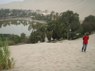
Our next stop on the way up north has been the city of Ica in the coastal desert region. There is not much to do in Ica, mostly destroyed during the 2007 earthquake (that also mangled Pisco) except for the curiosity, oasis of Huacachina, a couple of kilometers to the west.

Huacachina used to be a natural oasis in the middle of the dunes that quickly transported one to the middle of a Sahara. An old legend says that it was formed after a disconsolate green-eyed girl cried here the death of her Inca general lover. In the 1940ies Huacachina became an exclusive spot where wealthy Peruvians would come for a balneary experience. However, due to intensive agriculture around Ica, the lake has drained, and now has been replaced by an artificial one, with not that much of its old green color left. The hotels and restaurants have aged as well, the earthquake did not help.


Meanwhile, the fun is had by all on the outskirts, in the dunes. You can rent a sandboard with scratches instead of fixings for 5 soles a day, and go into the dunes. Nevertheless, going up the sand dunes is even less exciting than going up snow hills, so the privileged way of exploring the desert is going for a buggy ride. At first, it sounded to me like another very touristy thing to do, but to my surprise it proved to be a lot of fun.


The 2-hour buggy ride is more like the Russian Mountains in Disneyland. The vehicle itself resembles a submarine or a moon rocket, all open and very noisy. And than it goes rocket-like up and down the dunes. It is not for the people with cardio-vascular problems though. It starts being amusing only when you manage to convince your brain that it is not happening to you and that it is not a real vehicle and that there is a 100% security there despite those seat belt buckles that barely hold, and that crazy look in the driver´s eye.


From time to time, the driver stops at the edge of the biggest sand dune, and the entertainment starts - the sandboarding.


Having no experience with snowboard, i went at it in a slightly different manner. After a couple of descents even those with snowboard experience took at it in my way as it is the most painless, rapid, and enjoyable way to get down:


The buggy ride has thus been lots of fun, and we enjoyed a beautiful sunset in the end:


Thursday, July 10, 2008

Colca Canyon


The nearest attraction to Arequipa is the well-publicized Colca Canyon. It is supposedly one of the deepest canyons on Earth (just behind the Cotahuasi canyon near-by the peruvians say), although we did not find it that impressive or that deep.

It takes around 4 hours to get to the village of Chivay by bus, in the middle of the canyon. It is a big hole of nothing, so it is worth continuing to the last accessible by road village in the canyon, Cabanaconde. Not that there is much more to do in this village, but at least most of the hikes start here. It is also the closest point to the main attraction in the canyon, condor watching.

Peruvians have been quick to understand the appeal of the condors, and there is thus a 35 sol per person fee collected at Cruz del Condor, the condor Mirador, from which one can see condors going on their early food pursuits from around 8 30 to 10am. Being poor and rebellious, we decided to snap a couple of pictures and sternly refused to pay the fee.


The next objective has been to go down the canyon, around 1000 meters down to the river and around to the villages on the other side. The surprise came when, after 4 hours of descent, at the bridge crossing to the other side of the canyon, an official asked us about our 35 sol tickets...Did i mention we only had enough soles for our return bus ticket? Anyway, we refused again (this payment was mentioned only for condor viewing in all our guides, and not for trekking), and could henceforth not cross the bridge. We saw another pass down the river, which we followed putting our adventurers´sombreros on. After some exploring, we finally found this make-shift bridge and bravely crossed it:


The rest of the hike went on more like planned, and we reached the Paraiso oasis we were aiming for at the end of the day. Camping there was expensive (7 soles per tent!), but hey, this is a tourist paradise, so there. At least there was this likable alpaca rambling around our tent all night and letting us snap a few pictures of its lovely furry self:


Overall, we found Colca Canyon a bit over hyped. Oh, the last adventure, while sleeping in Cabanaconde´s hotel, Renaud woke me up in the middle of the night saying there was an earthquake. I hardly believed him, although our bed did seem to move just a little bit. And finally, here it is - the 6 earthquake in southern Peru...

Arequipa

We have started our journey back up North and the city of Arequipa has been on our minds. It is the second-biggest city of Peru, and definitely worth a stop. Not only is it clean, white, and of manageable dimensions, it also offers a superb cuisine and desserts. Enough to make us salivate and rest a couple of days. In addition, there is the Monasterio de Santa Catalina.

This abbey has been founded quickly after the Conquistadors arrived in the country. Evangelizing of the locals was one of the stated purposes and importing the main catholic ideas, such as Jesuits and abbeys, rapidly became a fashion. Thus, in 1579, first three nuns started developing what later became a real citadel in the center of Arequipa. It has been open to the public only in 1970, 390 years after it was founded.

There are still around 20 nuns living in the Northern corner of the abbey, but today it is mainly a tourist attraction. The abbey itself is a puzzle of multicolored streets and squares, a wonderful architectural feat and a place to let your mind wonder around, replete with images of the past. It is very well restored, and early birds get the place almost to themselves.

The nuns in this abbey used to come from rather rich families, and at a certain time had up to 4 slaves attending them. Hence, they built a women´s kingdom, beautiful to the eye and soul. The dowry they were supposed to bring to the abbey with them was about 2 400 silver (potosian) coins, or around $50 000 today. About 450 people are said to have lived in the abbey at its peak (one third nuns, the rest slaves), although it has been reformed in the 19th century to combat the opulence by a nun sent directly by the Pope from Rome. It still does look like a place from Marquez´s novellas, and one just can´t stop wondering what the life inside these doors must have been like.


Arequipa is a rare Peruvian city full of charm. Although el Misti, its famous, Fuji-like volcano, does not have a gram of snow anymore, it is still a pleasure to wonder through its streets and admire its whitish buildings, made out of sillar, a white volcanic rock from a quarry near-by.

Saturday, July 05, 2008

Potosi and the Mines

After having our full of Bolivia, we headed back to Peru. But first, another short stop at the city of Potosi. Never heard of it? However, this is where all the silver that made Spain empire prosper for over 300 years since the 16th century came from. It is also a 160 000-person city with a cemetery of over 4 000 000...There is always a price to pay.


This (ironically) smiling face shines over the door to Casa de la Moneda, the biggest remaining baroque building on the continent - and for a reason. This place is where all those silver bars and coins were forged when Cerro Rico, the mine, was still full of the precious metal. First globalization attempt, silver coins from Potosi were used not only in Europe, but also in Asia, Japan, and surly the New World. Numerous adventurers (also called pirates) hunted for them all over the world too.


The Cerro Rico, here it is below, or what remains of it after the centuries of mining. Mining is allowed under the 4 400 meters mark (the mountain goes up to 4 800 meters), and some say tunnels go as much as 1 000 meters down, and many many kilometers in circumference. This mountain allowed Potosi to be as big (200 000 inhabitants) in the 17th century and at least as rich as London or Paris at the same moment in history.


Visiting Potosi mines is a harrowing experience. Still around 20 000 miners exploit the mine (it mainly yields zinc now) in conditions almost equal to the ones a couple of centuries ago. Dynamite is used, otherwise everything else is mainly done by hand. Miners are organized in cooperatives, and the mine belongs to them, not that that changes much to their lifestyle.


In our Westerner eyes it is hard to comprehend why someone would voluntary work in a place where the average life expectancy is 45 years, where we, unaccustomed strangers, felt our lungs as polluted as after 10 years of chain smoking and lost our voices following only a 2hr visit. Dust is everywhere, air is brought in in rubber tubes, but it hardly reaches all the holes that painfully allow thin bodies to pass grudgingly, going from cold to warm and in the opposite direction, like rats digging themselves in this big shithole. All that willingly and knowingly...I guess if we paid 80 bolivianos for the experience, it might be possible to comprehend, just slightly reaching the top of the iceberg of human motivation, why someone would choose to make a living out of it.


Apparently Incas knew about the mine as well, but as the legend says, a voice told them not to exploit it as it was for other men. Soon upon their arrival, Spanish discovered the mine (with help of willing locals). Those same locals were forced to work gratuitously the mine, with only payment being candles and coca leaves. That is also when coca became such a popular plant. Before its anesthetic qualities were known only to Inca elite. Spanish quickly noticed that coca use inhibited hunger and made one work for much longer periods of time. First, the church prohibited it as a pagan witchcraft, but rapidly the conquistadors persuaded the inquisition to allow its use in the dogmas, and started themselves selling the leaves to the berated miners.


Since then, coca has entered in the popular use all over Bolivia and Peru, and has helped the Spanish to extract the silver. Black slaves, brought to Potosi at first to help in the extraction, never managed to acclimatize, and either died off or moved to the Yungas regions to grow that same coca for the more resistant locals. Thus, it was left to the native population to make Europe rich (and inflation-rich too). Which they did, at an estimated cost of 8 000 000 dead.

Another particularity of the mine is its god Tio, or the devil himself. As no woman is allowed to work the mine (if she does, the metal will disappear!), the men found themselves a god of their own, a red-eyed, horned and big-pennissed Tio. His effigies can be found around numerous corridors, ranging from a man-sized figures to small dolls.


**********************

On a more cheery note, one of the biggest Galleons, called Nuestra Senora de Atocha, carrying the Potosi silver to Spain sank around Florida. After a long search, the galleon's remains have been finally discovered in 1986 by Mel Fisher and friends and have been considered the biggest treasure of the known world, valued at $400 000 000. Of the treasure, Key West museum of Florida has thoughtfully sent 3 coins to the Casa de la Moneda museum in Potosi. Oh, our just world...As Gandhi said, civilization? that would be a good idea...