Tuesday, July 01, 2008

Bolivia, La Paz and Around

After Puno, we were seduced by the proximity of La Paz (only 5 hours away). I had to get a Bolivian visa first. It proved to be rather easy and surprisingly free. The only hassle was getting a yellow fever vaccine, which i did in a hospital for 3 sols ($1). Thus, the unplanned journey into Bolivia began.

Bolivia is a special place, like Aron Ralston calls it, between a rock and a hard place. It is the South American Tibet, one of the highest countries of the world - and one that possesses a part of the Amazonian jungle as well. A country of paradoxes, it has furnished Spain for centuries with its silver and prosperity, it is today one of the poorest on the continent. It has also recently elected Evo Morales, the first indigenous president, that rallies for the people, against the US, friends with Cuba and Venezuela...Below is a picture of the people, a street pop corn vendor and her customer from the bourgeoisie:


Our first stop has been La Paz. The main objective there has been mountain biking through the Death Road, Renaud´s idea. The Death Road used to officially be the most dangerous road in Latin America, as the Inter-American Development Bank statistics stated. Those same statistics said around 200 people were killed there yearly from car, truck and motorcycle traffic (see here for more). In this great new century, after an IFM grant and over 20 years of construction effort, a new road has been opened in 2006, and thus leaving the Death Road to the mountain bikers and their support vehicles.


It is the road going from La Paz, on the West side of Cordiliera Real mountain range, to the village of Coroico, on the east side of the range, where the jungle starts. This whole jungle region is called the Yungas, also famous for its coca growing traditions. The biking starts from the high point of a pass at 4 600 meters at La Cumbre, goes down for 24 asphalted kilometers, and then down more 36 non asphalted old Death Road, to finish at 1 200 meters above sea level. An overall 60km descent, usually done in 4 to 5 hours.


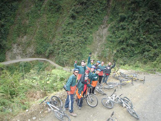
This circuit is usually accomplished through a travel agency with a group of 9 people, two guides, and a support van that drives behind the group in case of a problem. We paid around $45 per person with El Solario, nice agency, for the fun or the suffering, whatever way you like it. The first half was relatively easy and benign. The second part is the business. The road enters the jungle, wet, misty and unforgiving. It is also unpaved and full of gravels - perfect for mountain biking enthusiasts or those who enjoy making their butt suffer. And here is our proud group in the middle of the descent:


I wished i were more expert at the mountain biking, but the couple of times out with Renaud in Belgian plains seemed to have sufficed to make me able to go down safely, if not quickly. Below is Renaud enjoying himself on the final stretch. All the pictures are courtesy of our guide from El Solario.


The view of the road and its famous drop offs. We did not exactly realize that it looked like this when posing for this picture!


Friday, June 27, 2008

Inti Raymi


Inti Raymi was an Inca religious celebration giving thanks to the sun god Inti. It corresponded to the harvesting period, the New Andean year, and the winter solstice here. Last authentic celebration took place in 1535, since when it has been forbidden by the Spanish.


With the arrival of the tourist age, Cusco has reawakened the old tradition and transformed it into a dress-up folklore party and a happy gathering for the tourists. It is a long ceremony full of colorful parading, dancing, and music.


Today, June 24th is the day of the main celebration. The carefully chosen Inca and his wife are carried from the Qoriqancha, the temple of the Sun, to Cusco´s Plaza di Armas, and then to the sacsayhuaman fortress high above the city. The Inca gives a speech here and there about the rulings of the land, and finally a lama sacrifice is performed at the fortress to interpret the omens about the year to come. On Cusco streets several fiestas and various parades, especially around the Plaza di Armas, can be witnessed for several days before and after the main event.


There are a lot of local villagers that come to the capital (Cusco) for the celebration as well as tourists. The costumes are numerous, very colorful and intricate, - and for once it is not required to pay to take pictures!


Unfortunately before and after the celebration life is still rather hard for the locals, and it is better to pay for a picture, if not you get assailed by a couple of hungry children, like we did after taking this picture (by Renaud):

Titicaca Lake and its Islands

Next stop on our trip after Cusco is the city of Puno. The biggest attraction of Puno is the access it gives to the Titicaca lake. We arrived late and went directly to the Duque Inn, a nice cheap place 3 quatras from the Plaza di Armas. At the hotel, they had already a tour package ready, so at 7 30 am next morning we departed for a 2 day islands tour.

We spent the first day on Amantani, the island the furthest from Puno (4 hours boat ride), where we were awarded a host family for lunch, dinner, and night. Our 22-year old mom, with a 3-year old daughter, made us potatoes and cheese and brought us to the fiesta in the evening, sharing her clothes to dress us up and make the tourists happy. She revealed being paid only 25 soles ($4) for the job of taking care of the two of us, but that is tourist business´s way. Below are the happy dressed-up tourists:


But first on our boat journey we stopped at the Uros islands, or the floating islands of the Titikaka lake. Uros people decided to live on the water for unknown reasons long time ago. Since, the real Uros-speaking population has itself disappeared. The aymara locals continued the traditional way of living on the islands, however the Uros language has been lost since 1960s.

The islands, made out of totora plant, last around 25 years. The base is made of totora roots, the top of totora stems, added every week. The islands are around 2m thick and support around 7 families. If the families do not get along, it is a traditional way to cut the island to accommodate everyone! Now they mainly live out of tourism. Each day boats coming from Puno bring visitors, that are welcomed in the fashion below:

There are over 45 islands, and the main problem today for the population is ... dental care because of all the sweets the tourists bring with them! Otherwise it is definitely an interesting spot to visit and to feel the totora under one´s foot. We even took a boat ride on a totora boat, with this beautiful girl rowing all the way for us:


As i said earlier, we spent the rest of the first day on the Amantani island. The highpoint has been the sunset, seen from the top of one of the island´s hills, whose top is still at 4100 meters, as high as Mont Blanc du Tacul back home. Below is myself, on the hike up the hill, with Titikaka and Cordiliera Real in Bolivia behind me:


Titikaka actually means Puma in Stone. There is a legend that before being a lake, this region used to be a fertile and happy valley. The only requirement God put on the people living in the valley was not to climb the mountains around it to look for the sacred fire that supposedly awaited them on top. For may centuries people followed the good advice and did not climb the mountains. The valley remained prosperous and green. However, the evil spirits came over, attracted by so much well-being. They seduced the people with tales about the sacred fire, and convinced them to climb up. As soon as the men started up, God sent pumas to the valley, and they destroyed the fertile valley and its inhabitants. Inti, the sun god, saw the disaster, and cried so much, that Titikaka lake was formed, and all the pumas were turned into stone. Only a man and a woman stayed alive - but never again could they return to the fertile valley...


On the morning of the second day we left for Taquile, the island seen in the middle of the picture below. Actually our host mom with her cousin and her mother are knitting here. Women all wear beautiful costumes with skirts and flower-embroidered blouses. The black shawl comes from the Spanish, that themselves borrowed it from the Moorish women they invaded before coming to the New World. Thus, a part of the Arabic heritage can be found on the shores of the Titikaka...


Taquile is known for its textiles, which have been declared Unesco heritage. This is one of the rare places where men wear traditional costumes as well and proudly display their hats. One of the reasons is that you can tell if they are single or not by looking at those hats - the man on the left on the picture is single, the one on the right is married!

After the Taquile visit, it is time again to return and go elsewhere. The beautiful arches of Taquile lead us to our boat and back to Puno:


New adventures await...

Monday, June 23, 2008

Choquequirao, Another Lost City

Machu Picchu not being enough to satisfy our fondness of the Inca empire, we decided to do a real trek, and go to Choquequirao, another not so lost ancient city in the mountains. This city is only accessible by foot, although that does not stop wealthy tourists, who hire donkeys that carry them all the way up and down the 32 km trek. We decided to rough it and go on our own, with tent and all. Here is the courageous Renaud starting out the trek, with beautiful Cordiliera in the background:

Choquequirao has actually been known to our civilized world for much longer than Machu Picchu. Actually, Machu Picchu ´discoverer´, Hiram Bingham, was first sent to Choquequirao by the locals while on his quest for the lost city of the Incas. This city´s legend says that it was the last city to be inhabited by the real Incas after the Spanish took over their empire, for no less than forty years. As always in Peru, without written testimonies, much is left for the guessing.

Since 2002, a lot of archaeological work has been performed on the site, with the help from the French government. As the story goes, it´s Peru´s ex-president Toledo´s Belgian wife that has spoken about Choquequirao to Chirac, and as he was also well-read and interested in the project, mainly due to some French explorers that have visited and written about the city in the 19th century, it went underway. Some unique mural decorations of 23 lamas and a human figure have since been discovered on lower agricultural terraces. (We failed to see them as we learned the whole story at Marco´s hotel, see below for his website).

We stayed only a short afternoon at the sight, as it is much smaller than Machu Picchu. Below is the view of the ceremonial terrace, where Incas probably worshiped Inti, the sun god.


We actually trekked through a loop, starting at the village of Cachora, and ending at Huanipaca. Usual trekkers, monopolized by the Cachorian donkeys and their guides, are taken up and down the same trail from Cachora. When we asked our way to Tambobamba, several locals told us not to go that way, without really explaining why it was so peligroso. As we found out later, the trail is used by Peruvians only (women, children, donkeys), and is guarded as a strict secret for some reason (probably having to do with the Cachorians willing to keep their monopoly).

We enjoyed the Tambobamba return a lot, passing through a lavish ex-hacienda of San Ignacio, still growing oranges, tomatoes and coca plants. We did enjoy a couple of succulent oranges on the way too! To top the experience, we stayed at a very pleasant hotel run by an escaped italian Marco in the village of Tambobamba, please visit him if you are around. His website has further information about Choquequirao as well. We finished the trek with another 10km hike up to Huanipaca, where a 20 soles taxi took us to Abancay, and then back to the Cusquena base.

*********
Before visiting Choquequirao, we also went on a day hike to Moray terraces and then Maras Salinas. We did got lost on that hike and did 2 hours of extra walking, but the views were not too bad. Here is a quechua woman with Nevado Salkantay in the background, near the Moray terraces:

And below are the Salinas, used since the pre-inca times to gather salt from the spring in the mountain. Great trail for mountain biking as well:

Thursday, June 19, 2008

Machu Picchu, the Wonder


As all the guidebooks say, one can not go to Peru and not visit Machu Picchu, the site that has been voted one of the new seven wonders of the world. This old Inka city was discovered by the Western civilization only in 1911, when an American explorer Hiram Bingham first wandered through the lower terraces, cultivated at that time by a couple of quechua families. It is supposed that the city was actually abandoned by the Incas for some obscure reason just before the Spanish conquest, and that is why it has been preserved unnoticed for such a long time.

There are several theories or legends as to the purpose of the city and its quick demise. Bingam thought it was the Inca religious center, where the Virgins of the Sun lived. Out of the 100 bodies found on the site, 80 were mummies of women. Others thought of the city as a prison for select few rebelious Inca aristocrats, or as a mountainous estate for one of the rulers. As Incas did not develop any writing, much if not most historic information has been lost, only conjectures of more or less gifted archaeologists remain. Read here for further MP history background.

However, MP did not stay unnoticed for much longer. The 20th century saw an explosion of tourism to Machu Picchu, making the town of Cusco rise out of its provincial ashes, recover and proudly display its Inca heritage, filling in the meantime the pockets of a couple of enlightened businessmen, i.e. PeruRail. The only way to get to Machu Picchu is either by train or by foot, following what is now known as the Inca Trail (30km trek that has been so crowded lately that the Peruvian government had to allow only 400 trekkers per day, with permit issues and tour agencies´prices exploding consequently). Fortunately there are a couple of other different trails leading to MP, that take longer and do not require a permit.

We decided to take the train though due to time and planning issues. This train is the biggest discrimination of them all in Peru - it costs 15 soles ($5) for Peruvians to take it from Cusco to Machu Picchu, and over $80 for the rich outsiders like ourselves...The train actually brings you to the village of Aguas Calientes, down in the canyon, at the base of MP. From there, one can take a bus to the entrance of MP, for only...$14 both ways. We preferred walking up the old Inca steps, a not so bad 1.5 hour approach. Machu Picchu is reputed to be most strikingly beautiful during the sunrise, that is why we started at around 4:30 am from Aguas Calientes, to be at the entrance gate at 6 am. The entrance itself is $40 per person so far, with rumor having it going up to $70 in July...One of the most expensive places i have visited - it even beats DisneyLand!

End of money rent, back to the site itself. The first denizens we walked into upon the opening were these guys:

They guarded the entrance to the hike up Huayna Picchu, the big mountain seen in all the classic pictures of MP. Machu Picchu is situated in a saddle between Huayna, the young, and Machu, the old, mountains. The view from the top of Huayna Picchu is less classic but as beautiful:

For me, the most mysterious and enchanting spot in the Lost City has been in the vicinity of the sacred stone in the picture below. The stone was apparently used for telling different seasons and times to plant various plants (mainly corn and potatoes). It is situated on the highest point of the MP temple terrace and does have something unreal about it:

Visiting MP is rather tiring, as routes go up and down all the time. By noon we were happy to take a nap on one of the terraces, with this view at our feet:


It is rare though to have a picture without tourists crowding around. Usually it looks more like the picture below, with the Japanese play dolls this time. It is unfortunately very characteristic of MP nowadays, with more than 3000 visitors crowding the city each day:


After the MP visit it is nice to stop at Aguas Calientes hot springs (overpriced, as everything around here), and have a free Pisco Sour at one of the numerous restaurants, that offer free drinks to make you come into their door.

Monday, June 16, 2008

Pisaq, the Ruins

The most interesting sight we have visited so far has been the village of Pisaq and its Inca ruins. The village is situated at the bottom of the Sacred Valley, venerated by the incas, and now a rather poor mountainous place. The ruins though are situated higher up, 300m over the village, overlooking the river and making the imagination work. Below is a picture of one of rare still standing walls of the Sun Temple, accessible through a tunnel dug in the rocky mountain side:

Further down are the terraces that have remained since the civilization collapsed. Rests of an Inca village can be seen in the upper part of the picture. On a side note, the colors are really amazing in this country - maybe it is the altitude - picture taking is a pleasure here!


Lastly, here is my favorite Inca wall in Cuzco:


Saturday, June 14, 2008

Peru, the Trip

This is my second big planned trip for this summer - a prolonged visit to Peru. I have been fascinated with this country for some time now, with another planned visit that has failed two years ago. Now is the time - and i am well in !Peru¡


It has been a long flight through Sao Paolo, the third biggest city in the world (behind Tokyo and Mehico city), of which i saw none. Sao Paolo's airport is very sad though, small and unhappy-feeling. Therefore it has been a pleasure landing in Lima´s newly refurbished, yellow-orangy airport, apparently redone by a dutch company.

Lima is not a very exciting city either. We stayed in Miraflores barrio and did not even have time/will to go all the way to Lima city center. First of all it is just too big. I like cities that one can discover on foot, rambling through streets and avenues, and not having to worry too much about how to retrace one's steps. Not so in Lima - it is huge (over 10 million inhabitants), full of cars and activity, and grey. Its famous mist was at rendez-vous, making even the Pacific ocean seem melancholic and dead. Maybe all those shopping areas at Largo Mar did not exactly help.

Anyway, next day in the early morning we quickly flew off to Cuzco, the touristic heart of Peru. First surprise, our plane had to turn back after circling the Cuzco airport a couple of times as a storm did not permit landing. We flew back to Lima, and then back to Cuzco again, making up for a 5-hour flight instead of the promised one. Latin America, continent of patience, we are learning! (Picture of Cuzco's Plaza de Armas with the main cathedral on the left, and the Jesuit church on the right)


We did finally arrive - only to start feeling dizzy and headachy because of the altitude (3 400m). Two days since we are here, and our touristy enthusiasm dies around noon, and all plans are sliced in two by siesta and early bed time. We did manage to visit some museums around town and the Inca ruins of Tambomachay and Saqsqywaman (reads like sexy woman) so far. They were not that impressive, so i will stick with Cuzco for my pictures - cathedral, once again:


Peru is subversive - one can eat here a menu for lunch with a soup, meat, dessert and a drink for 1 euro, but the tourist ticket to visit the surrounding treasures (or rather bunches of stones barely standing together) costs almost 20 euros, and that is not to mention Matchu Pitchu, a totally different matter, the most expensive place on earth to visit in my book so far.

Peru does remind me of Ukraine, with its collectivos minibuses used for transportation, big SUV cars and poor people all around, nuns and churches everywhere. However in Cuzco they have learned the tourist lesson well. Not only can you take a picture for 1 sol with a lama and a pretty dressed-up young girl or an old and ugly grand'ma spitting coca leaves (your choice), but they also close all their churches and ask you for money to visit them after 10 am, practice the discriminatory pricing to tourists vs. indigenous people everywhere, and overall keep asking you for money all the time and everywhere. End of rant or should i say to be continued...

Tuesday, June 10, 2008

M

Now that i started with Music, i have to continue, with someone like M, or Mathieu Chedid. I discovered M while watching les Triplettes de Belleville in Boston, and he's been on my favorites list since.

Simple or not, i love the song and the video (remake of Sean Lennon's English-speaking Parachutes), especially the donkey! No doubt, it's Balthazar!!!


Sunday, June 08, 2008

Têtes Raides and Dionysos

What unites Têtes Raides and Dionysos? Olivia Ruiz bien sûr!

The new album by Dionysos, Mecaniques du Coeur, very much inspired by Tim Burton's aesthetics, is telling the story of Little Jack and Miss Acacia, based on a script written by the lead singer, Mathias. It is said to soon become a movie with help from M. Besson (check here for more info). Their previous album, Monsters in Love, made me think of Behemoth from Master and Margarita. The new one develops the theme...To listen to some of their music, check myspace. Below is Candy Lady, a nice duo by Olivia and Mathias:


Banco is the new album by Têtes Raides, also with participation of Olivia. You can listen to some of their music on myspace, such as Explusez-moi or Banco. Plus Haut or Je Chante (video below) is their duo with Olivia, also surprisingly good!

Thursday, June 05, 2008

Travel Resume - Other Europe

Belgium:
- climbing in Freyr
- Ducasse de Mons
- Primitifs Flamands
- Ensor
- Magritte
- Couleur Café
- Africa Museum


Germany:
- Kohln cathedral;


Greece  
- Kalymnos, Cicati Cave, and more
- Meteora 


Italy:
- Florence

- Rome and its museums
- Vatican
- Dolomites first time with Cory, 2005 (Piz Ciaves, Tre Cime)
- Dolomites with Christian, 2006 (Tower of Babel at Ciavetta)
- Dolomites once more, with Cathy, 2009 (Brenta, Rosengarten)
- Arco

 Norway:
- sportcliming in Gullknausen
- small big-walling on Hollenderan
- Lofoten

Sweden:
- sport climbing at Niemesel/Northern Sweden
- bouldering near Umea
- Swedish Christmas

Denmark:
- Copenhaguen

UK:
- Edinburgh

Tcheque Republic
- visit to Prague

Travels through Ukraine:
- Kyiv
- Lviv 08' and some more 09'
- Carpathians
- you can find my resume of climbing in Ukraine on rockclimbing.com


Other
- Andorra

Travel Resume - France

France is a perfect destination for climbing, mountaineering or plain old tourism. Here is an attempt at a resume...

Pyrenees and South-West:
- Aguille d'Ansaberre climb
Gorges de la Jonte climbing
- Gorges du Tarn
Gorges de Cesse et de l'Aveyron (St. Antonin)
- Gorges de Lot (St Gery)
- Targassonne bouldering

Provence and more South:
- Aix en Provence tourism
- Buoux climbing
- Seynes climbing
- Provence visit 2009, Dentelles de Montmirail
- Verdon

Calanques climbing:
- First time with Gabe (traversée sans retour, la Candelle)
- Calanques with Alex (pour la mémoire de nos enfants)
Futurs Croulants, Devençon

Around Grenoble (Vercors, Ceuse etc):
- ice in Champseur near Gap;
- Mont Aiguille, Trois Becs, Ombleze
- Presles

Chamonix: 
- Ski touring Flaine and Fiz- Ski touring in Aiguilles Rouges around Mont Blanc;
- Ski touring Gervasutti and brêche Piseux;
- Fil a Plomb goulotte
- Envers des Aiguilles rock climbing in and again in 2009
- Gran Capucin, Adolphe Rey and Dent du Geant
- Brevent and Eperon Migot
- Lake Lemans

Aravis:
- Tours d'Arreau
- Gramusset
- Sapey
- Ice in Reposoir

Ecrins:
- Cerces
- Tête d'Aval and Ponteil

Fontainebleau bouldering:
in winter and again
in autumn

Alsace:
- Windstein and Langenfels climbing
- Wachtfels, Ansberg and Kronthal

Other:
- Paris tourism
- Prevert minute

Travel Resume - Switzerland

I have been to Switzerland on several occasions, mainly climbing or ski touring. For a climbing overview, please see my Switzerland page at rockclimbing.com.

Climbing:
- Gastlosen near Jaun pass
- Clocher du Portalet and Aiguilles Dorees and again for Etat de Choc
- Eldorado, Grimsel pass
- Furka pass


Ski Touring:
- Wildhorn traverse
- Dent de Morcles
- Dents du Midi
- Titlis tour
- Berner Oberland, Finsternaahorn;
- Glarner Alps, Clausen pass;
- Wildstrubel, Kandersteg
- Travels around Andermatt, Uri/Grison

Travel Resume - the Americas

USA:
I traveled to Yosemite National Park for a month in May 2008:
- Yosemite Valley and its how to
- Sequoias
- climbing Geek Tower
- climbing Half Dome
- climbing El Cap
- visiting San Francisco

- Christmas in NYC

Canada:

I traveled to Canadian Rockies in September 2007:
- These are my first impressions
- more about climbing (Grand Sentinel),
- hotsprings;
- climbing Mount Louis;
- climbing in Skaha
- climbing around Squamish and Squamish 2
- Vancouver and its art
- Victoria and Vancouver island
- Rockies sightseeing;
- Group of Seven painting
- and finally some useful information/random thoughts...until next trip!

Peru:

I travelled to Peru and Bolivia in June-August 2008:
- first impressions
- ruins of Pisaq
- Machu Picchu visit
- Choquequirao trek
- Inti Raymi festival in Cusco
- Titikaka, floating islands, Tequile and Amantani
- Arequipa tourism
- Colca Canyon trekking
- Ica and Huacachina, or the sandboarding
- Musts of Peru and Bolivia
Mountaineering in Cordiliera Blanca:
- Pisco 5760 meters, PD+
- Esfinge, 5320 meters, 6c
- Quitaraju 6040 meters, D-

Bolivia:

I travelled to Peru and Bolivia in June-August 2008:
- La Paz and mountain biking the Death Road
- Salar de Uyuni and South Lipez
- Potosi and its Mines

Sunday, June 01, 2008

San Francisco

Last stop on the Yosemite trip, San Francisco treated us with the usual clouds and mist to prepare for the Belgian climate back home. We put on our tourist hat and went into the city. Having both been there before, we decided to discover San Fran by bike. It is popular and thus easy to rent a bike for a full day and there are numerous bike paths around the city. The main attraction is crossing the Golden Gate Bridge on bike. The views are gorgeous, and you can visit the yaht town paradise Sausalito and come back by ferry.


Biking through the city from the Ferry Building, we went up the hill to Alamo square, to see these Painted Ladies, reminiscent of Bostonian Victorian architecture. My bike is in the center of the picture!

The day not being over yet, we did another popular biking loop, going to the Golden Gate park, San Francisco's way of building a Central Park, and then back again to the Golden Gate through chique quarters of the city this time. Here is the bridge again, from the other side and with less clouds, the same day:


The biggest impression that San Fran has left in my mind this time though, is composed of its homeless people. The picture below comes from the grass in front of the City Hall, not far from our hostel. Either American economy is doing really poorly, or the mayor of the city needs to be sacked, but the situation is incredible. Having been to Vancouver and its East End, San Fran beats all comparison. I kept my eyes down in shame in front of all these blacks (mainly), whites, and hispanics, laying down and sleeping around on the streets. In popular tourist districts, as well as in residential areas or on main shopping streets - they were everywhere. Sad place, country of opportunity in this shape...


Despite the homeless, there are many worthwhile things to visit in the city. I spent the whole day waiting for my evening plane, in the Asian Art Museum that has moved in 2003 to a building redesigned by Gae Aulenti in front of the City Hall (she is the one who redesigned such buildings as Barcelona's Museum of Catalan Art on Montjuic, Paris's Musée d'Orsay and Centre Pompidou). The collections and its caffetera are great. We enjoyed ourselves, and immersed into the American culture. Here is Renaud remembering how to eat a serious hamburger:


That much for the USA travel, till next time!

Saturday, May 24, 2008

Sequoias of California

Sequoias are the largest living beings, and some of the tallest trees as well. They disappeared after the ice age from everywhere except the Sierra range in California. Some sequoias still alive today are thought to be between 3 000 and 4 000 years old.

Mariposa Grove, one of the first sequoia groves visited by non-Native Americans in 1850s, is situated in the south-western part of the Yosemite National Park. This is us under the Fallen Monarch, that has supposedly capsized over 300 years ago. The remains of fallen trees can linger, if undisturbed, for unknown periods of time. Note the not that profound root system of the 1000 ton tree. This grove was one of the investigators to the creation of the National Park system in the USA.


It is a delight to wonder among these lost dinosaurs of the mainland. This is how the place looks like today - and probably looked like in 1850, when the cabin was initially built by Galen Clark:

To get to Mariposa Grove, we had to hitch hike. Hitch hiking is a very interesting activity, at least around Yosemite. Each time we tried, we always got picked up by either climbers or other strangers in the land, such as Polish, Turkish, and finally Swiss girls. Are Americans becoming less friendly in these terrorism and fear-filled years? If so it is a shame!

Last shot, an echo to Rowell's picture of a Jeffrey Pine on Taft Point that i only saw afterwards, is of this Jeffrey Pine we saw on the descent from Half Dome. Not as big as the sequoias, but certainly as beautiful!

How To: Surviving a Month in Yosemite

Having spent over five weeks in the valley, it is interesting to share our practical experience with the wanna-be wall rats. Here you go from the first hands:

1. Shelter
Lodging is probably the easiest and most attractive part of the Valley. Camp 4 (called Sunnyside Campground for some time) is considered a historic climbers campground, after the authorities tried to close it a couple of years ago, and the climbing community made itself heard to proclaim it a historic sight. Maybe a far cry, but it is rather fortunate that the campsite has remained as other accommodations in the park are rather expensive. Its main advantage is the price - $5 per night per person that is hard to beat anywhere today.

Unfortunately that comes with certain disadvantages. Camp 4 is a walk-in campground, meaning that you walk to the ranger's office in the morning, queue and get a site on first-come first-served basis. The inconveniene of the system is the queue that gets sometimes very long and slow - i had to queue from 7 in the morning to at least 10 to get a site sometimes. Another problem is the 7-day limit stay. It is only enforced during peak season, from May 1st to September 30th. From October to end of April there is no ranger and self-registration with envelopes in a box is applied, a very likeable system indeed!

When there are rules, there are always ways to circumnavigate them. First of all, there is no computer or other motorized way to keep track of the campers. Rangers rely mainly on the faces and current IDs (unfortunately IDs are required to register) to tell you to go away. After the 7th day you still have 2 days' notice, and on the 9th day only your tent gets confiscated. The usual way is to register on one person's name, spend 5-6 days in camp, get on a big wall for a couple of days to get forgotten by the ranger, come back and register on another person's name for a week, repeat ad infinitum and actually pay $5 per night for two people...Or not register at all - with 35 sights and 6 people per sight, there is little manageable way to identify the unregistered users. Use this advice at your own risk!

This is our tent at Camp 4, where we stayed registered for the whole 5 weeks without too much ado or any administrative problems:


Different lodging options are 3 other campsites ($20 per night per site) that have to be reserved in advance, Housekeeping camp and Curry Village (least expensive if not camping, $70 per night for the cabin), Yosemite Lodge (over $100 per night hotel), and the Ahwahnee Hotel (over $500 per night).

2. Food

Most of the time we would cook at our campsite, buying groceires at the Village Store - a descent size supermarket, although rather expensive. Best option is to get groceries outside the park, however you need a car for that.

There are several possibilities for eating out. Our favorite price to quality mix was degnan's deli's large pizza with peppers sausage mushrooms. For $20 it makes a perfectly full stomach for two hungry dirt bags. The Mexican place at Curry Village has great Taco salads that can be eaten comfortably by two for lunch. There is a coffee and ice cream corner at Curry as well.

3. Transport and Maintenance
There are free hybrid shuttles functioning from camp 4 to Curry Village, around other stops in the park from 7 am to 10 pm, making it very convenient to live car-less inside the valley. To get there from San Francisco we used Amtrak (take BART from the airport to Richmond, board train there) to Merced and YARTS to Yosemite. From 9 to 6 there is also a shuttle going from the Visitor Center, stop at camp 4, to Manure Pile Buttress parking area - best way to access El Cap and Cathedrals if willing to walk or hitch hike.

There are wonderful hot free showers at Curry Village, later in the season they also have a pool there. There is laundry at the Housekeeping Camp. Internet (25c a minute) is available at Yosemite Lodge and Degnan's Deli. There is also free internet at special opening hours at the girls club library (ladies room) opposite the Visitor Center, a rather secret location that takes some time to locate!

4. Rest Days and Sightseeing
There is not exactly tons to do during the rest days. Visiting Ansel Adams Gallery is an intellectual pleasure. They also have a good collection of books for sale. There is also a free movie to see at the airconditioned theatre of the Visitor Center. Not far by, there is a cemetary, and as impressive Indian Museum.

Hiking is a more interesting option, though it's not exactly rest. Exploring and photographying various falls (Ribbon, Bridal Veil, Yosemite, Vernal, Nevada...) might become a hobby in itself, especially during spring time. Mirror Lake trail makes you leave the crowds of the shops just to find the hiking crowds. Little Yosemite Valley hike is definitely worth it, especially if you do not do the Half Dome descent at any point. It is also worth driving to the Glacier Point overlook when the road is opened, the views are fantastic. Mariposa Groove also requires hitch hiking to see the Sequoias. Toulomne Meadow is further down the road, that is usually closed until end of May.

Sunday, May 18, 2008

Yosemite Falls, Geek Tower

One of the landmarks of the Yosemite park is the Yosemite Falls. It is the fourth or fifth tallest falls in the world (Angel Falls in Venezuala holds the first place), falling down a total of 740 meters overall if adding its three levels together. It inspires any park visitors to become instant photographers as it is visible from many corners of the park and presents different perspectives during different times of the year or even day. This is my meager take on the subject:


We could not resist either the temptation to go up there with our ropes and try climbing something in the proximity. We first aimed at Freeblast, however after the first pitch of run out 5.10-11 climbing we quickly changed to the Center Route, an easier neighbor. It still presented a 5.10a offwidth that made both of us suffer as suffer you might only on a 50m Yosemite classic offwidth pitch. The exposure and views were definitely worth the effort though:


We made it to the top of the Geek tower, a less apparent mini-summit to the left of the Lost Arrow Spire, and had the pleasure to see double rainbows over the falls throughout the climbing day (i am also climbing in the picture below):


In love with the place, here is another perspective of the falls from the hanging bridge near our camp. Geek tower is in the middle between the falls and the Lost Arrow Spire:


Last couple of days in the valley we spent doing shorter climbs or even parts of longer climbs we did not dare to completely commit to. We thus tried the first 4 pitches of a new route on the far left side of Lower Cathedral - a beautifully-colored, bolted 5.11 face leading to a crux 12a crack, and the first 5 pitches of DNB on Middle Cathedral. Another route led us to a real summit - South by Southwest on the Lower Cathedral Spire. It has one really good 11a thin hands crack pitch worth the approach.


Our last climb has been the famed Astroman, or rather its first 5 pitches. It is an awesome line, rather strenuous Enduro Corner, something worth training for. We have a reason to come back some day to dare finish and get into the Harding Slot!